Sanze’s Little Helper: Fantastic Fujikura-yama (Mt. Fujikura)
ふじくらやま

藤倉山
FUJIKURA-YAMA
Fun little peak in the tiny fishing village of Sanze, Tsuruoka City
Jump to My Guide to Hiking Fujikura-yama
While the Nichizoe Highway that cuts over and through the mountains to the south of central Tsuruoka is a bit of an eyesore, it’s almost entirely made up for with how easy it is to access the awesome little fishing village of Sanze and the nearby Fujikura-yama. In fact, of all the 100 Famous Mountains of Yamagata along the Shonai Coast, Fujikura-yama is by far the easiest to access. Just a short five minute drive from the Sanze Interchange and you’ll find yourself on the steep trails covered with cedar and beech forests that open up to unbeatable views.
The township of Sanze is well known for its beach complete with giant rocks to jump off into the ocean. Plus, the Sanze ski field to shred some snow in winter. It is also famous for one of the most popular ramen shops in all of Shonai. So, when I found out that there was a mountain near Sanze, I knew it would be worth checking out. This could not be truer with Fujikura-yama.
Fujikura-yama and the Famous five

Fujikura-yama is nestled in the hills behind the sheltered cove and fishing village of Sanze on The Sea of Japan. Sanze is right between Yura and Atsumi Onsen where Arakura-yama and Atsumi-dake lie. The Shonai coast is also home to Takadate-yama, and Kumanonaga-mine. While a little inland, Nihon-koku probably also deserves an honourable mention.
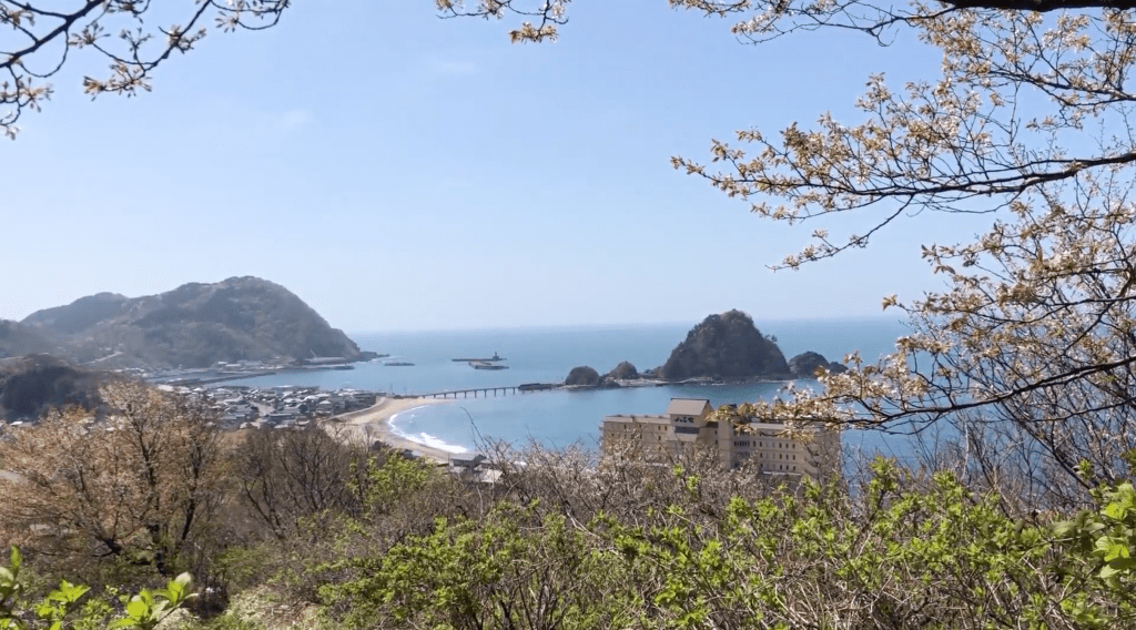
The mountains along this coast feature extensive beech forests interspersed with planted cedar forests. They all of course offer grand views over The Sea of Japan. In particular, Fujikura-yama commands views of the Sanze hamlet, The Sea of Japan, the Shonai Plains, Chokai-zan, Gassan, The Asahi and Ide Alps, Maya-san, and on fine days even out to the Oga peninsula in northern Akita Prefecture or Sado Island in Niigata Prefecture.
The Climate and Creatures of Fujikura-yama

Fujikura-yama is home to many varieties of wildlife such as the asian black bear, Japanese serow, and Hodgeson’s hawk eagle. The mountain is located in the middle of snow country with harsh winds, especially in the subalpine zone to the west. If you’re climbing any time of the year besides winter, you will be fine. It may even be worth doing some snowshoeing in the forests at the base. However, it would be a bit hard to get to the summit in the deep snow.

In spring, flowers such as the dogtooth violet bloom. In autumn the leaves change, and even the evergreen five-needle pines along the mountain ridge get in on the action.
The river that runs from Fujikura-yama helped sustain the agricultural and marine industries of Sanze for centuries. In addition, Fujikura-yama has mountains on all sides, which meant that my Horagai conch echoed amazingly.
My Guide to Hiking Fujikura-yama: Climbing Season

I timed my hike with a fine autumn day in early September knowing that I’d be able to see far. For the most part, I was right. Along the way, there were a few spots to take in the nearby township of Sanze. There were even spots to see Chokai-zan in all her glory. However, the foliage was very thick, and I had to do some Yamabushi gymnastics to get those views.
For Fujikura-yama, it’s definitely best to wait until some of the foliage has fallen in mid-to-late autumn. Or, get in there before it all starts in early spring. Not only will you have clearer trails, you’ll more easily be able to take in the views. If you’re there at the right time, they have a mountain ‘opening’ ceremony in May. There is also a ‘closing’ ceremony in November.
My Experience Climbing Fujikura-yama

I probably climbed Fujikura-yama at peak vegetation. That trail was narrow basically the whole way up. So narrow in fact that not only did I get bitten by about five or so leaches, I walked through at least a dozen spider webs, and saw two Mamushi pit vipers. I guess they were hanging out on a dead tree waiting for their next unsuspecting Yamabushi victim to just roll on by (thankfully they were pretty chill, and there was enough space for me to get past).
In other words, Fujikura-yama is a reminder that you can never be too prepared to climb mountains. I guess short socks and Skins just aren’t up to scratch. The Skins work well enough, although I have been bitten through them in the past. The problem was, short socks expose ankles, a godsend for any lurking leaches or other bugs in the thick bush. Needless to say, I bought some dedicated hiking pants. If you’re thinking of climbing Fujikura-yama, I’d say you’d be wise to do so too.

Trailheads up Fujikura-yama

Fujikura-yama is a pyramid-shaped mountain with two trails on either side. The Futakuchi trail starts to the west, and the Shishihata trail to the north. Both trails will take you about 90 minutes one-way. However, the Yamagatayama website says the Shishihata trail is 2 hours, and the Futakuchi three.
Let me tell you up front, you want to take the Futakuchi trail. Read on to find out why.
Getting to Fujikura-yama

Both trailheads up Fujikura-yama are located a short distance from the Sanze Interchange on the Nichizoe highway. In terms of distance that is.
Head south from Tsuruoka and get off at the Sanze Interchange. There is a ‘T’ intersection where the detailed signage to Fujikura-yama begins. From here, a left turn will take you to the Futakuchi Trailhead. A right turn will take you towards the Shishihata Trailhead, the one I very much mistakenly opted for.
If you’re wondering why, the Futakuchi trailhead is much much easier to get to. Basically, just follow the road that you are already on past the Sanze Ski Field. Five short minutes later you will arrive at the car park for the trailhead.
Getting to the Shishihata Trailhead on Fujikura-yama

The Shishihata trailhead is a completely different story. If like me you love idyllic Japanese countryside villages with small shrines and sprawling rice fields, but are fine with getting lost, twice, this is the path for you. My advice, take the Futakuchi Trailhead! Unless you love doing complicated algebra and calculus just to find a mountain path!
Google Maps can't be trusted to find the Shishihata Trailhead. The route stops right before a gravel road you need to travel down. If you want to take this trail, first make your way to the Minashi Shrine. This shrine is located where the normal road ends and the gravel road begins on Google Maps.
Minashi Shrine on the way to the Shishihata Trailhead of Fujikura-yama

To get to the Minashi Shrine, coming off the highway at the Sanze Interchange, take a right at the ‘T’ intersection and follow the road under said highway. Eventually, you will arrive at the Sanze township. Now, you’re going to have to have a keen eye to look out for all the signs to Fujikura-yama. I missed one and ended up taking a farm road way up into the rice fields unnecessarily. No wonder the farmers were staring at me, although I did get some good footage for my Instagram stories.
When I say you need a keen eye, trust me, you need a keen eye. Keep an eye out for the Fujikura signs that can be hard to spot on the narrow village streets. Eventually, you should end up on a road that takes you through a tunnel that goes under the highway again. Once through the tunnel, you will see the Torii shrine gates on the left. This shrine has a few tiny Hokora shrines, and is a fun spot for a little exploration.
Onwards to the Shishihata Trailhead

From there, follow the gravel road about 2 or 3 clicks alongside the forest and through the rice fields. Although in a really beautiful area, this road is not exactly well looked after. There were a lot of potholes, and you have to be very careful not to do any damage to the underside of your car.
It’s best if you have a 4WD for this. I can imagine it would be easy to get stuck on wet days. As I said, the Futakuchi Trailhead is by far the better option. At the end of this forest road there is a car park for maybe 3 or 4 cars, and the Shishihata Trailhead is right there, complete with signage for the trail.
Climbing Fujikura-yama from the Shishihata Trailhead

The climb up Fujikura-yama from the Shishihata Trailhead was a combination of intense cardio workout and dense mountain forests. At the start, there is a planted cedar forest with cedars as straight as a needle, quite common for providing Japan with the lumber it needs. Just in case, if you ever get lost but do see a cedar forest like this it means a road for logging is nearby.
About two minutes up the Shishihata trail there is a fork in the road, with the right path leading up the mountain, and the left path a giant cedar and the origin of the Minagawa River. On the way back to my car I tried climbing up to the giant cedar, but it was too overgrown and I didn’t get very far.
Yamabushi Tip: How to deal with Blood-Sucking Leaches

To get to the cedar I had to walk in the river at parts, and in the grasses along the banks, which is most likely where the leaches got me. Thankfully it was at the end of the hike so I could easily deal with them, although one did manage to find its way under my toe, ouch!
Here’s a Yamabushi tip, bring salt with you, preferably in a spray bottle with water. Spray that on the little blood-suckers if they bite you and they will quickly curl up and die.
Mountain Streams and Cedar forests

The cedar forest doesn’t last very long, maybe 10 minutes, just where the trail starts to get very steep and you find yourself in the much-awaited beech forest shortly after. Essentially, you follow a ridge line up this beech forest for the majority of the climb. This is where the path gets very narrow, for the majority of the hike the path is only wide enough for one person, if that.

Scaring off the Bears of Fujikura-yama and Coming Face to Face with Mamushi Pit Vipers

To be honest, I did get a little freaked out here as I was on my own and wasn’t sure what kind of creatures I would encounter. I had heard that there were black bears on Fujikura-yama, so I blew my conch quite a few times in this area. It must be the shape of the surrounding mountains, but the echo I got when I blew the conch was some of the best echo I had ever heard.
Unfortunately, since snakes lack an outer ear, so my inspired conch blowing didn’t do a good job of scaring away the two Mamushi pit vipers I came across lying on a dead tree. Luckily that part of the path was wide enough for me to get past without getting too close.
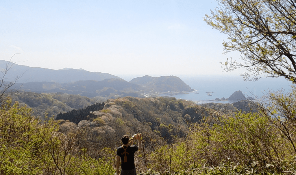
The view from Fujikura-yama

Besides the Mamushi, and walking through a few dozen spider webs (and whenever possible under or around), the path is rather uneventful. Until you reach the lookout that is. Along the way, Fujikura-yama has some really good views of Sanze, Yura, the Sea of Japan, and a few times I was able to catch glimpses of Chokai-zan through the thick bush.
Just after the sign saying ‘you are now as high as the Tokyo Sky Tree’, there is one section where you have to use a rope to climb some steep steps that had been dug into the mountain. Shortly thereafter was a lookout that had a letterbox for you to leave a note, and you are essentially at the summit of Fujikura-yama.
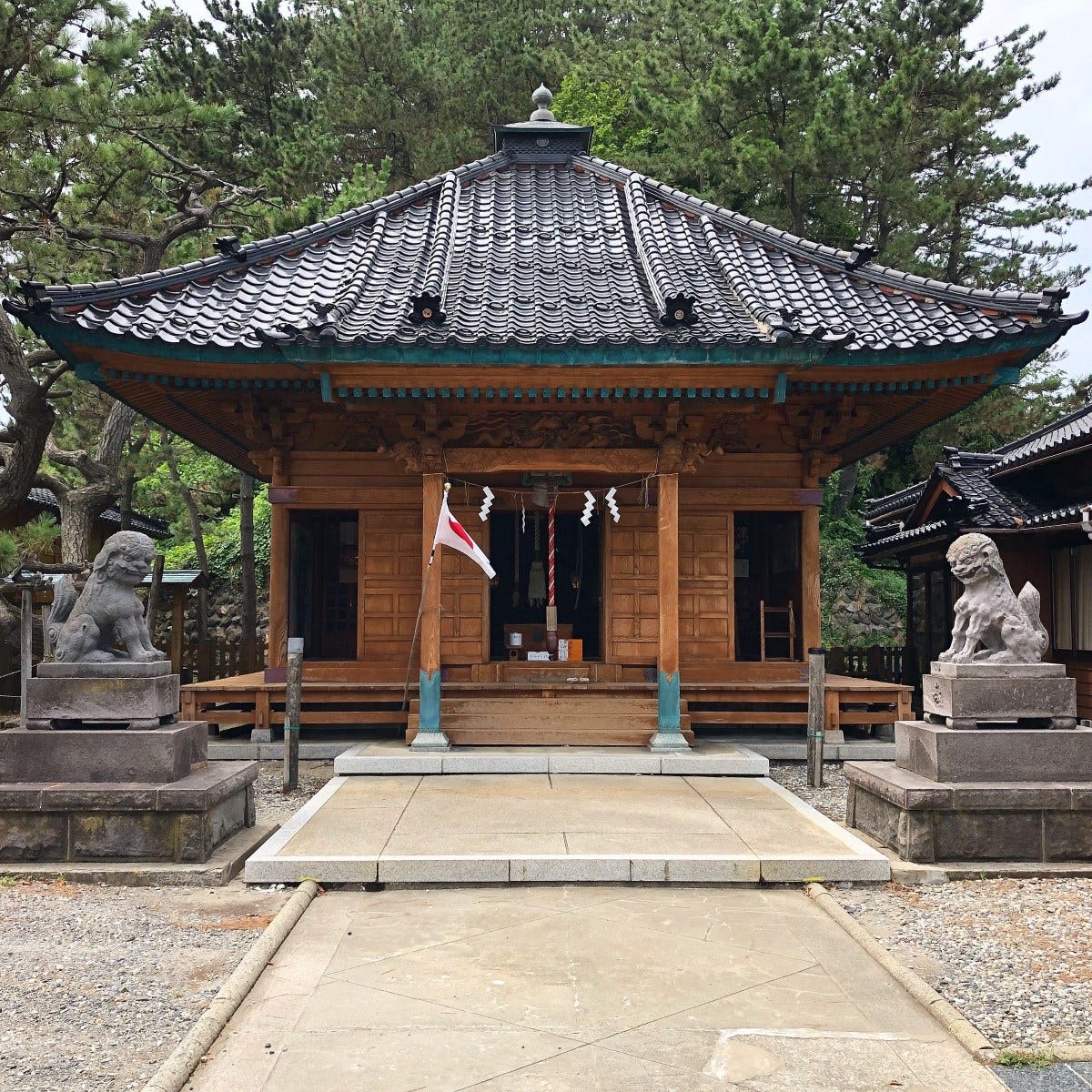
Or so they would lead you to believe. The real summit is about 50m away, where there is a clearing in the beach forest that holds a few Hokora Shrines dedicated to Yakushi Nyorai, the Honji Buddha of Fujikura-yama.
Hike time up Fujikura-yama

Here I came across the only other people I saw on the mountain, a group of three men who had climbed from the Futakuchi Trailhead. The men told me their hike from the Futakuchi trailhead had taken them a little over an hour, which was considerably shorter than the three hours it said on the yamagatayama website. Similarly, my hike from the Shishihata route had taken about 90 minutes including getting footage, still shorter than the 2 hours quoted.
After dedicating my rituals to the Buddha and Kami, I headed back down the mountain largely uneventfully, besides going slow where I had spotted the Mamushi Pit Vipers and blowing my conch a few times to scare off any bears lurking around.
Heading home from Fujikura-yama

Once I got back to the cedar forest I decided to check out the giant cedar and origin of the Minagawa River, but that didn’t go as planned and I didn’t get very far at all.
If there was less foliage, it might be a good idea to check this out, but only if you have long socks and the proper leggings to avoid the leaches. From here it’s just a matter of retracing your steps back to the township of Sanze, and the Nichizoe highway.
Nearby places worth checking out
The Beach Village of Sanze

The beach and fishing village of Sanze itself is quite a popular spot throughout the year, particularly during the heat of summer. The people of Shonai know Sanze for its famous rocks in the middle of the bay for jumping into the Sea of Japan. Sanze beach is a popular spot amongst surfers, and I’ve even seen some dedicated souls head out into the waves in the middle of winter while snow still settled along the coast. Not to mention, Sanze is also home to the famous ramen joint Konpiraso, a ramen shop only open in winter that boasts classic Shonai ramen flavours and attracts people from all over.

Speaking of winter, the tiny village of Sanze even has its own ski field, a small strip of clear land cut among the cedar forests overlooking the tiny fishing village. This ski field was undoubtedly popular in the past, being so close to central Tsuruoka and the surrounding coastal towns. The Sanze ski field is instantly recognisable in the warmer months with the giant smiley-face cut into the grass, something for people to catch as they drive past.
Hakusan Island and Yura
Known for the beautiful Hakusan Shrine on Hakusan Island that juts out into the ocean and is connected with its characteristic red bridge, Yura is another fishing village located just to the north of Sanze. On good days, you can even get amazing views of Chokai-zan from there. The village of Yura is also famous for its Onsen Hot Pools, such as Yurayaotome (Japanese website, I’m in one of the videos), and as the landing spot of Prince Hachiko, founder of the Dewa Sanzan.
Arakura-yama and Arakura Shrine
Arakura-yama has a trailhead from Yura, and is one of my favourite mountains in the whole of Shonai. After about 2 hours of hiking from Yura, you will find Arakura Shrine, one of the Shonai region’s hidden gems, and well worth a visit.
Kumanonaga-mine

Fujikura-yama isn’t too far away from Kumanonaga-mine, another peak where we encountered pit vipers and leaches. Kumanonaga-mine is a very short hike, and you could easily do both of these peaks on the same day.
Maya-san

Located more inland, Maya-san is one of the more popular mountains in the Shonai region among locals. A former Shugendo mountain in Kinbo Shugen, the 1019m high Maya-san is another great spot to check out the autumn leaves. From Fujikura-yama, the Koesawa and Sekigawa Trailheads up Maya-san are only about a 20 minute drive.
Atsumi-dake and Atsumi Onsen

A short 20 minutes drive south of Fujikura-yama and you will find yourself in Atsumi Onsen, home to another 100 Famous Mountains of Yamagata, Atsumi-dake. Atsumi-dake is famous for its long mountain stream and as a former Shugendo mountain complete with Kumano Shrine and decommissioned Shukubo pilgrim lodge.
Atsumi Onsen is one of Tsuruoka City’s three Onsen towns (the other two being Yutagawa, and Yunohama), and is the coolest places in the Shonai region. Located at the southern end of Tsuruoka, with only Nezugaseki further south, Atsumi Onsen is a great spot for a walk amongst the Sakura in spring, or a visit to the rose garden in June. While you’re there though, if you’re not staying at Tachibanaya with their awesome onsen, do be sure to check out Chitto Mocche, a locally-run cafe that is famous for its outdoor foot baths.
The Fishing Town of Nezugaseki
Nezugaseki is the town at the southernmost point of Tsuruoka City’s Shonai coast, and was once one of the main checkpoints into the Ou region (the other two were in Shirakawa and Nakosonoseki). According to local legend, Nezugaseki was the checkpoint where the events of the famous Kabuki play Kanjincho took place.
The tiny fishing village of Nezugaseki has a few peculiarities worth checking out, such as Itsukushima Shrine, the Nenjunomatsu Garden, and Asahiya Sushi Restaurant. Itsukushima Shrine isn’t that grand, but it has many cool statues and artefacts and juts out on the coast where there is a pretty cool lighthouse to explore.
FUJIKURA-YAMA
藤倉山 | ふじくらやま
Mt. Fujikura, Mt. Fujikurayama, Mt. Fujikura-yama, Fujikurayama
Fujikura-yama (藤倉山ふじくらやま) is a 654m (2145 ft.) peak in the Shonai region of Yamagata prefecture best climbed from May to early November. Mt. Fujikura is a level 2 in terms of physical demand, which means it is relatively easy to hike, has an A technical grade, which means it requires little expertise. You want to allow at least 2 hours one-way for a climb.
Mountain Range
Fujikura-yama
Region
Shonai
Elevation
654m (2145 ft.)
Technical Demand
A (requires little expertise)
Physical Demand
Level 2 (a little tough)
Trails
1) Futakuchi Trail (2 hours one-way) 2) Shishihata Trail (to be avoided! 2 hours one-way)
Best time to climb
May to early November
Day trip possible?
Yes
Minimum Time Required
2 hours one-way on the Futakuchi Trail
PDF Maps by TheHokkaidoCartographer and JapanWilds.org. See all here.


YAMABUSHI NEWSLETTER
KIWI YAMABUSHI

TIM BUNTING - KIWI YAMABUSHI