
Why Climb Hokari-yama?
Hokari-yama has a legendary namesake as part of the Kinbo Shugen mountains alongside Kinbo-san, Yoroga-mine, Yunosawa-dake, and Maya-san. It is especially beautiful among the autumn leaves, and you can even do a traverse down to Kinbo-san passing through Yoroga-mine.
In spite of its strange name, literally Mother Hunter Mountain, Hokari-yama has a really great trail through a deciduous forest leading the whole way to the summit from the Tanisada Trailhead in Kushibiki, Tsuruoka City.
- Legendary namesake
- Spectacular autumn leaves
- Mountains that branch off the Asahi Mountain Range
Where is Hokari-yama?
Hokari-yama is in Kushibiki, in the south of Tsuruoka City. The Tanisada Trail leads through a deciduous forest practically all the way to the summit.
Hokari-yama is part of the Kinbo Shugen group of mountains that lead up to Maya-san. After Kinbo-san, you will find Yoroga-mine before reaching Hokari-yama. Then there is Yunosawa-dake before Maya-san, although I’m not sure Yunosawa-dake and Maya-san are connected by trails.
Here are the co-ordinates to Hokari-yama
When can I climb Hokari-yama?
Hokari-yama is open for hiking from April to November, although you’d probably want to wait until the snow has melted.
How Can I Get to Hokari-yama?
Once in the Tanisada hamlet, there is a farm road that goes up into the mountain, just up past Mitake shrine. This road takes you through some rice fields and other farmland at the foot of Hokari-yama, whose two humps at the summit are recognisable from miles away. Keep following this road up into the mountain and you will find yourself in a cedar forest that leads up a gravel road to a dam. This is where the road stops, and since there are no signs it’s hard to know for sure, but this is the Tanisada Trailhead up Hokari-yama.
There is only enough space for two or three cars up here, even less if it’s wet and muddy, so you may need to park further down the road a little bit and walk up. While there are no signs, behind this dam is where the trail starts proper.
What are the main trails?
While there are officially two trailheads up Hokari-yama, The Tanisada Trailhead, and the Nagataki Trailhead, the Nagataki Trailhead is overgrown, and as such is not recommended at the current moment. The Tanisada Trailhead, however, is a great little hike, especially amongst the autumn leaves. The Tanisada Trail takes about 3 hours one-way.
WHAT IS HIKING HOKARI-YAMA FROM THE TANISADA TRAILHEAD LIKE?
Hokari-yama comes with a huge warning: The Tanisada trail was barely signposted, so you’re definitely going to want to go with someone experienced, or with a detailed map, to make sure you’re going the right way. We spent the first 40 minutes going to a dead end, and that was following what was a clear trail. Either way, this mountain is as good a spot as any in Yamagata to take in the autumn leaves, so it was definitely not time wasted!
Although it starts out at a dam, The Tanisada Trailhead up Hokari-yama is really quite gorgeous. Just make sure you go the right way. For starters, you have to know how to get there. If you’re going to climb Hokari-yama, go with someone who has experience climbing this mountain specifically, or make sure you use a map on the trail, such as the one from the YAMAP app (although, it did get me lost on the way there). Regardless, this mountain is not for beginners.
If you don’t have this assistance, you risk going on a 40 minute trail to nowhere like we did, and if you’re not careful, you may also end up going down the completely wrong mountain like we nearly did. The signage on Hokari-yama simply didn’t exist, and if we hadn’t used the YAMAP app, in all truth, we probably wouldn’t have been able to find the way up.
In all honesty, I tried hiking Hokari-yama twice. The first time I went by myself and the rain got really bad basically as soon as I had arrived. I wasn’t prepared to film in the conditions, so I turned back. Thankfully this gave me the chance to be certain I had the right trailhead, although as previously mentioned, there were no signs and I inevitably got lost.
What happened was, I plugged the link from the YAMAP app into Google maps, but it turns out this only made things worse. I spent about 20 minutes navigating a gravel road deep in a cedar forest, only to realise the map had taken me up the wrong gravel road. I only found my way to the right gravel road by tracing the road from the YAMAP app back to my current location, and I must say for an app with a white background, light grey is not a good colour for roads.
I got to the trailhead in the end, and went up the path probably 100m only to realise I was going to get very wet. So I made the executive decision to turn back and come another day.
That other day came very soon, and thankfully this time I knew exactly where Peeter and I needed to go. However, as strange as it sounds, our first mistake was following the trail as per normal. What I should have done is kept checking the YAMAP app. If I had done so, we probably would have noticed the pink markers much sooner. There were no signs at this point, so you absolutely must use a map on Hokari-yama!
The one path we originally found wasn’t all that bad though. It took us to another dam about 20 minutes up into the mountain. Thankfully the view was amazing; mountain stream, waterfalls, and of course the autumn leaves. However, it was only once we reached the dam, which turned out to be a dead end, that we realised we were headed in the wrong direction.
So, naturally, we retraced our steps, and in the middle of the bush found the markers that designate the correct trail. No signage or anything, just a muddy path you can barely make out in the middle of some very thick bush!
The day we went was after a few days of rain, and the trail was extremely slippery. We basically walked on the branches of trees for a lot of this part of the trail because it was the only way to guarantee we wouldn’t slip.
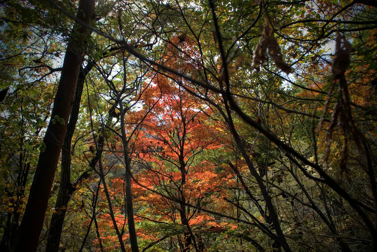
After navigating the slippery slides for about 10 minutes, thankfully the path became much more bearable, and we found ourselves in the middle of one of the most beautiful forests to be in during the autumn leaves. We followed the trail through a canopy of bright reds, yellows, oranges, and greens, and it made that struggle at the start very much worth it. This path lasts for quite a while, as the leaves on the trees little by little become barer and barer.
The climb up Hokari-yama intensifies
You need your wits about you for the next section. Before long, the trail comes to the very narrow ridge of the mountain, just wide enough for one person to navigate with sheer drops on either side.
Then, there are a few areas with tall beech trees and steep inclines requiring ropes to get up. Make sure you use these ropes, we slipped a few times while trying to get a good grip. After a few sections of rope, the trail meets what seems to be another trail, but is just an extension of the ridge that will take you essentially to the summit.
Here you take a right, and basically just keep heading up. Along the way there is another trail that loops back to the trailhead, we only knew this because we came across a group of hikers who told us, and actually handed us a map as they were on their way down. I have no idea where that trail comes out, but they had parked their cars at the same place as us, so there’s that.
Then, you just keep following the ridge up towards the summit of Hokari-yama and before long the trees open up enough to give a really grand view of Yoroga-mine, Kinbo-zan, Tsuruoka City, the Shonai Plains, and Chokai-zan far off in the distance.
What is the summit of Hokari-yama like?
This part of the climb was rather tough, there were a few points that looked like the summit but until you reach them you find out that they aren’t. This part of the path doesn’t take you all the way to the summit; there is a ‘T’ intersection at the top from where a right turn takes you down to Yoroga-mine and Kinbo-zan. The summit is only another 3 minutes to the left from here.
At the summit of Hokari-yama there is a small clearing complete with sign and grand views of Gassan and the surrounding rice fields and tiny farming villages characteristic of the land.
I dedicated my prayers to the mountain of the moon (Gassan), and we both grabbed some lunch before turning around and slowly making our way back down.
What was it like hiking Hokari-yama?
Hokari-yama was a really good challenge that was well rewarded with stunning views of the autumn leaves and out over the surrounding land. Although the mountain has a strange name, this means it has some history, and it was fun to imagine the two Abe brothers on the ‘hunt’ for their mother (see the story of Hokari-yama).
Given the choice, I would hike Hokari-yama again, now that I know which path to take. But before that, I’d probably like to try and do a traverse, taking two cars and climbing from Yunosawa-dake to Kinbo-zan, passing by Hokari-yama. Obviously this would take much longer, but I think it would also be a really great way to take in the Kinbo Shugen mountains.
What is Worth Checking Out Near Hokari-yama?
The Yamabushi trails of Kinbo-zan
Hokari-yama is basically in the middle of the Kinbo Shugen mountains leading from Kinbo-zan at the base to Maya-san along the Asahi Mountain Range. Between Kinbo-zan and Hokari-yama lies Yoroga-mine, the mountain of armour, and between Hokari-yama and Maya-san lies Yunosawa-dake, another 100 Famous Mountain of Yamagata.
It should be possible to climb from Kinbo-zan to Maya-san, however I believe it would take a very long time, and you may be forced to stay on the mountain somewhere.
It’s best to do these mountains separately, or to do a ‘traverse’ which was recommended to me by someone who had a say in which mountains were to become the 100 Famous Mountains of Yamagata. To do this, take two cars, drop one off at Kinbo-zan, and go from Yunosawa-dake or Hokari-yama from the eastern side, climbing down to Kinbo-zan where you can pick up the other cars.
Bananas and Cokes, Leaches and Pit Vipers; Kumanonaga-mine
Hokari-yama is located directly to the east of Kumanonagamine, another peak along the Shonai Coast of the Sea of Japan. As such, it would be easier to get to Kumanonaga-mine if you were to climb from the western side, but it’s not too far of a stretch to get there. Kumanonaga-mine is a tiny peak that can be climbed in an hour or two, so is less of a challenge, but has wetlands that sure are a great place to explore.
Conquering Japan on Nihon-koku
If you’re looking for a shorter mountain to climb, Nihon-koku takes about one hour to get up, so two hours return, and is not too far away from Hokari-yama, relatively speaking (if you’re on the eastern side, you’ll have to double-round to the west, but that doesn’t take too long).
Nihon-koku is another 100 Famous Mountains of Yamagata list, Nihon-koku. Nihon-koku literally means ‘The Country of Japan’, so if you hike to its summit, you can truthfully say ‘I conquered Japan’.
Yutagawa Onsen
If you’re looking for somewhere to relax after a long hike on Hokari-yama, nearby Yutagawa Onsen will be your best bet. Yutagawa Onsen is one of Tsuruoka City’s three Onsen towns (the other two being Atsumi Onsen, and Yunohama), and is one of the coolest tiny townships in the whole Shonai region.
In Yutagawa, you will find one of my favourite Ryokan (Traditional Japanese Inn) in the region, Tsukasaya. Tsukasaya is run by the young Shoji family, and provides excellent cuisine foraged straight from the surrounding area (including Moso bamboo from Kinbo-zan in the Spring).
Takehiko Shoji, the husband, is a fellow Yamabushi and even a professional Sake sommelier, so he will definitely be able to find you something great to drink. Kanae Shoji, the wife, is fluent in English and has extensive experience serving Japanese and non-Japanese guests alike. In addition, the Ryokan has recently gone through renovations to be like brand new.
Atsumi Onsen and Atsumi-dake
Located at the southern end of Tsuruoka, with only Nezugaseki further south, Atsumi Onsen is a great spot for a walk amongst the Sakura in spring, or a visit to the rose garden in June. While you’re there though, if you’re not staying at Tachibanaya with their awesome onsen, do be sure to check out Chitto Mocche, a locally-run cafe that is famous for its outdoor foot baths.
For nearby mountains, and ones that are definitely worth the effort, Atsumi-dake is one of the 100 Famous Mountains of Yamagata located in Atsumi Onsen. Atsumi-dake is famous for its long mountain stream and as a former Shugendo mountain complete with Kumano Shrine and decommissioned Shukubo pilgrim lodge.
The Fishing Village of Nezugaseki
Nezugaseki is the town at the southernmost point of Tsuruoka City’s Shonai coast, and was once one of the main checkpoints into the Ou region (the other two were in Shirakawa and Nakosonoseki). According to local legend, Nezugaseki was the checkpoint where the events of the famous Kabuki play Kanjincho took place.
The tiny fishing village of Nezugaseki has a few peculiarities worth checking out, such as Itsukushima Shrine, the Nenjunomatsu Garden, and Asahiya Sushi Restaurant. Itsukushima Shrine isn’t that grand, but it has many cool statues and artefacts and juts out on the coast where there is a pretty cool lighthouse to explore.