This is How I Conquered Japan!
にほんこく

日本国
NIHON-KOKU
How to conquer Japan in 60 short minutes
Jump to My Guide to Hiking Nihon-koku
Judging by the fact that North America has hundreds of names for snow due to the sheer variety and amount, a country covered in mountains should naturally have tons of names for mountains. And for Japan, that just so happens to be the case. For example, there is Yama, 山, with its on-yomi reading of San. Take or Dake,岳 referring to more of a cliff face. Or Mine, 峰, also read as ho, bo, or po, that translates to the English peak. However, Nihon-koku is a Koku, 国, a country or state. Why?
Three prevalent theories exist.
Why name a mountain a country?
Theory One: The Shogun and the Falcon

The first theory, and my favourite one, is from the latter years of the Edo period (1603–1868). Legend has it a that famous hunter named Endo Taroji caught a remarkable falcon at the summit of Nihon-koku. Then, Endo did what any loyal citizen would. He presented the falcon to Tokugawa Ieharu, the tenth Tokugawa Shogun and de facto ruler of Japan at the time. Taken aback, Tokugawa proclaimed ‘This falcon is unmatched on heaven and earth! From here on out, the mountain from where this amazing beast came shall be Nihon-koku, the country of Japan!
Theory Two: The Founder of the Dewa Sanzan did it
The next theory as to how Nihon-koku became Nihon-koku is perhaps more convincing of a reason. I first talked about this a bit in the article on Haguro-san. According to legend, Prince Hachiko declared the Dewa Sanzan open for spiritual worship way back in 593.
Prince Hachiko allegedly passed away on Haguro-san at the age of 53. Sometime late in his life, Prince Hachiko stood at the top of Nihon-koku. He then pointed in the direction of his birthplace, Asuka in Nara Prefecture. Here, the prince declared ‘from this point south is Nihon-koku, the country of Japan!’.
And that's how Nihon-koku got its name.
Apparently.
Theory Three: The Border Between Yamato and the Emishi Tribes of the North
The third theory is seemingly the most plausible. After Prince Hachiko passed away, The Yamatao Imperial Court enacted the Taika Reform of 645. Before then, the Yamato established The Iwafune Palisades in a strategic position in the region of Iwafune in Murakami City, Niigata Prefecture.
At that time, Yamato Japan was ruled from Asuka, Nara Prefecture. It just so happened that anywhere north of Nihon-koku was not officially part of Yamato Japan. Rather, tribes of native Japanese Emishi or Ezo controlled the area. These tribes inhabited the Japanese archipelago long before the Yayoi Japanese arrived from the mainland.
The Yamato had been trying to lay claim to both sides of Nihon-koku even as far back as 250AD. However, it wasn’t until the Heian Period (794 to 1185) that they expelled the “Barbarian” Emishi. That is when the northern part of Honshu officially became the Japan we know and love. Nihon-koku lies along the border, and since it was a part of Japan, they literally called it 'Japan'.
(Disclaimer: Nihon-koku does also have another name, Imakusa-yama, 石鉢山.)
Do you get something if you ‘conquer Japan’?

In the past, you received a flag if you summited Nihon-koku saying ‘I conquered Japan’. In 2013, they wanted to recreate the ‘I conquered Japan’ thing with certificates. However, there was some resistance to the term ‘conquer’. This was replaced with a ‘I reached the summit’ certificate. So, while you may not get the right certificate, you at least get to claim to conquer Japan.
Many mysteries remain as to the name of this peak. However, we do know mariners used the mountain as a landmark for centuries.
My Guide to Hiking Nihon-koku: Climbing Season

Nihon-koku is located in snow country, so isn’t open for hiking year-round. The official opening date for climbing coincides with the mountain's height: The fifth day of the fifth month. However, if you want you can climb it from as early as April. The mountain closes officially when the snow falls, usually mid-November. It should still be possible to snowshoe, although it is very steep indeed.
There are five mountains along the Shonai coast comparable in size and stature to Nihon-koku. They are Takadate-yama, Arakura-yama, Kumanonaga-mine, Fujikura-yama, and lastly Atsumi-dake. These mountains have extensive beech forests that are wonderful to explore. Especially great is during the late spring when the greenery is out, and when the autumn leaves are on show.
Trailheads up Nihon-koku
There are three main trails up Nihon-koku. First is the Nakanomata trail from Tsuruoka City, Yamagata, to the north. Then there are the Omata and Zaodo trails from Murakami City in Niigata prefecture to the south.
From the summit of Nihon-koku, to the west we can see the Sea of Japan, Awashima and Sado Islands. Look to the north and you can see Chokai-san. To the east you can see Gassan and the Asahi Mountain Range.
Nakanomata Trailhead(1 hour one-way)

If you’re coming from the Yamagata side, you’ll want to hit up the Nakanomata Trail. Take note, getting there is truly half the adventure. The Nakanomata Trail begins in a small hamlet, Onabe. Onabe is a quaint hamlet deep in the mountains behind Nezugaseki. This is the southernmost township along the western Shonai coast of Tsuruoka City.
To get to Onabe from central Tsuruoka, you can either take the scenic route along the Sea of Japan, or the scenic route through the dozens of tiny farming villages. We opted to drive along the Sea of Japan on the way there, and to take the farming village route on the way back. Both are great options.
Getting to the Nakanomata Trailhead of Nihon-koku

From Onabe, take the road heading south towards Niigata Prefecture for about 1km. On the right-hand side you will see a split in the road. There is a gravel path through a forest that leads to the trailhead (with signs). If it’s been raining, be careful, this path is probably best suited to 4WD cars. It is also be possible to park here and walk if you need to.
About 500m down the forest path there is a car park for 3 cars, and the trailhead. The sign had fallen off the post and just lay on the ground, but it was still there. You’ll see a path that heads into the mountain on the left-hand side. Keep following this path and take a left into the forest.

The path will take you deep into the cedar forest with tons of switchbacks and a steep incline. Thankfully, there is only one path. It is easy to follow, but is quite steep so takes a lot out of you. Make sure you have correct footwear as the trail can be slippery in parts, even when dry.
Closer to the summit the trail goes through a beech forest. In retrospect the hike isn’t actually that long. It took us less than an hour to get up the path that the Yamagata website said would take 90minutes.
The Omata Trailhead (1 hour one-way)

The Omata Trail is one of two trails beginning on the Niigata Prefecture side. The trailhead is on the opposite side of the road from the Nihonkoku Fureai Park in Omata, Murakami City. The Omata trail is recognised as one of Niigata’s long-distance nature paths. It is an easy stroll up a slight incline through a dazzling forest.
Along the way, there is a ridge where you can see the Sea of Japan, and from the Janoge ridge. This is where the Omata trail meets the Zaodo Trail. From here, you can also see the Asahi Mountain Range in the distance. At the base of the mountain you can see the Nakanomata and Omata hamlets. From the Janoge ridge, the path goes down slightly. After that, there is an incline for about 100m to the summit.
Zao-do Trailhead (1 hour one-way)

Heading south from the Omata hamlet along the former Dewa Kaido path, the path to the Dewa Sanzan, you will find the Zaodo trailhead. The trail starts with a slight incline amongst a cedar forest, and passes the Zaodo (Zao Hall). The climb is tough in parts through a steep incline amongst the camellia trees, but once you’re through here there is a hut at the Janoge ridge from where you can take a rest as you enjoy the view. This is where the Zaodo and Omata trails meet. There is a downhill trail of about 1km connecting the Zaodo and Omata trails, so you can enjoy both trails quite easily.
Nihon-koku in conclusion

Nihon-koku is a brisk hike whichever trail you choose to tackle. Nihon-koku makes a great spot for some trail running, as the incline definitely gets your heart rate up but it isn’t a huge mountain by any stretch of the term. At the top there are a few clearings with benches from where the view over the Sea of Japan or the surrounding mountains is quite spectacular, making Nihon-koku a pretty good spot for a picnic as well. I think it’s worth climbing this mountain just to say you’ve conquered Japan.
Nearby Locations of Interest
Atsumi-dake and Atsumi Onsen

Located near Nihon-koku is the quaint hot spring town of Atsumi Onsen, in fact it is so close we went through Atsumi Onsen to get to there. Atsumi-dake is one of the 100 Famous Mountains of Yamagata and is located in the north of this hot spring town. As one of Tsuruoka City’s three Onsen towns (the other two being Yutagawa, and Yunohama), Atsumi Onsen is one of the coolest places in the Shonai region.
Located at the southern end of Tsuruoka, with only Nezugaseki further south, Atsumi Onsen is a great spot for a walk amongst the Sakura in spring, or a visit to the rose garden in June. While you’re there though, if you’re not staying at Tachibanaya with their awesome onsen, do be sure to check out Chitto Mocche, a locally-run cafe that is famous for its outdoor foot baths.
The Mountain Village of Yamairagawa

Yamairagawa is a small hamlet of only around 600 residents tucked in the mountains behind Atsumi onsen that apparently dates back to the Nara period. Famous for its Kabuki performances said to date back to the 1700s, including one famous performance for the Sokushinbutsu Tetsumonkai Shonin in thanks for helping the region avoid the plague. There has been a Kabuki competition since 1827 between the people of Warabino Village to the north and Sanemata Village to the south. Yamairagawa Kabuki and Yamato Noh are both performed in the area. Kabuki is a form of entertainment for the people, and Noh is always dedicated to the Kami gods.
The Port Town of Nezugaseki
Nezugaseki is the town at the southernmost point of Tsuruoka City’s Shonai coast, and was once one of the main checkpoints into the Ou region (the other two were in Shirakawa and Nakosonoseki). According to local legend, Nezugaseki was the checkpoint where the events of the famous Kabuki play Kanjincho took place. The tiny fishing village of Nezugaseki has a few peculiarities worth checking out, such as Itsukushima Shrine, the Nenjunomatsu Garden, and Asahiya Sushi Restaurant.
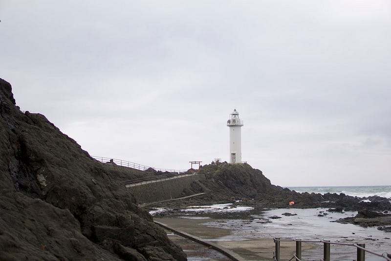
Itsukushima Shrine and the Lighthouse of Nezugaseki
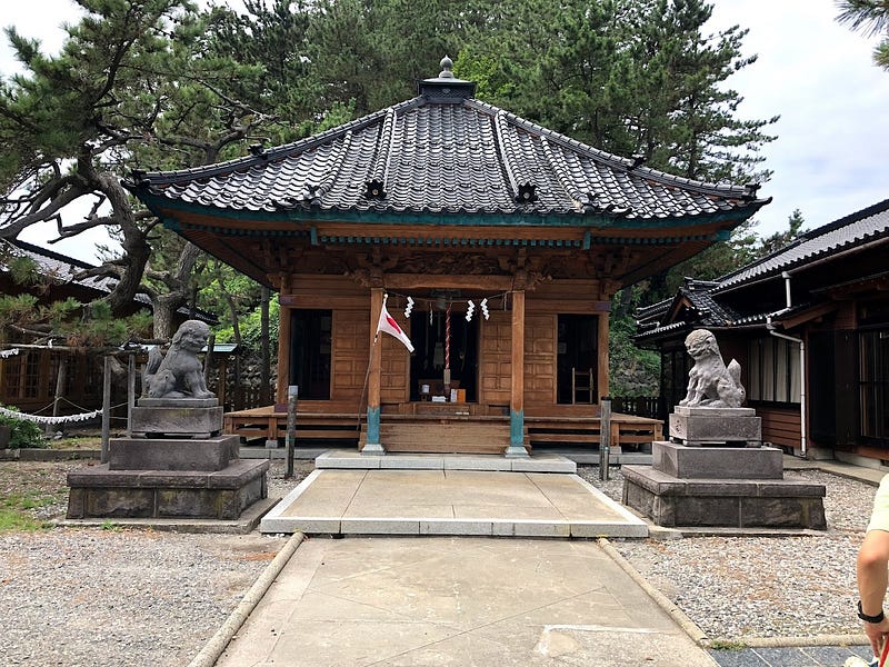
Itsukushima Shrine isn’t that grand, but it has many cool statues and artefacts and juts out on the coast where there is a pretty cool lighthouse to explore.
Nenjunomatsu Garden
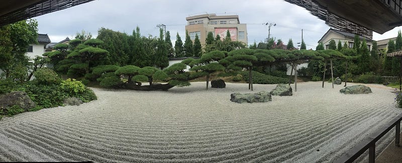
Nearby, there is a traditional Japanese garden called the Nenjunomatsu Garden, home to a very special 400-year-old Bonsai tree called the Nenjunomatsu (lit. the Buddhist Rosary Pine). What makes the Nenjunomatsu pine tree special is that it is less than 4m tall, but has one branch that stretches out 20m to the east. The diameter of the main trunk is 1.16m, but the one branch that sticks out has a diameter of 1.3m.
This is because the Nenjunomatsu Garden is actually the garden of a 400-year-old former Ryokan called Murakamiya that went out of business in 1960, but the garden and Bonsai were felt to be too special to destroy. The owner of the Ryokan requested the bonsai pine be a Garyu, a pine shaped like a dragon. The Nenjunomatsu is one of only 10 such Garyu in Japan, however none of them have a branch that reaches this length.
The Nenjunomatsu was registered as a natural monument of Yamagata prefecture on August 1, 1955, and the whole garden was redesigned by world-famous landscape architect Ken Nakajima in 1994.
Asahiya Sushi Restaurant
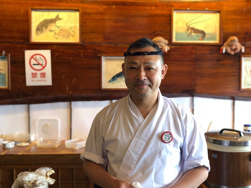
Nezugaseki is also home to one of my favourite sushi restaurants, Asahiya. Asahiya is owned by an eccentric sushi chef, one of the craziest guys I know who even hosts sushi parties on top of Maya-san, and who was enamoured by one of the Sokushinbutsu of Mt. Yudono, Tetsumonkai Shonin, and even has many of the actual tools used by Tetsumonkai Shonin as he trained to reach enlightenment in this current world. If you have a Japanese speaker, definitely take the time to listen to the chef’s speech if you can.
Murakami City
Murakami City has a done a great job in recent years preserving the olden-style cityscape with gorgeous traditional buildings. I’ve only been there once, but I knew I definitely wanted to come back. Murakami is famous for its dried salmon, you’ll find a few shops along the main street that are just full of salmon hanging from the ceiling. It’s great for lovers of the popular fish, but not so for those who get grossed out easily.
While not in Murakami, my wife and I had a really good time at Cafe Dal in Tainai City about 25 minutes away. Again we only went there once, but I remember thinking it was definitely visiting again.
NIHON-KOKU
日本国 | にほんこく
Mt. Nihonkoku, Nihonkoku, Nihongoku, Imakusa-yama
Nihon-koku (Mt. Nihonkoku, 日本国, にほんこく, にほんごく) is a 555m (1820 ft.) peak in the Shonai region of Yamagata prefecture best climbed from April to November. Nihon-koku is a level 1 in terms of physical demand, which means it is easy to hike, has an A technical grade, which means it requires little expertise, and you want to allow at least 1 hour one-way for a hike.
Mountain Range
Nihon-koku (also possibly the Asahi Mountain Range)
Region
Shonai
Elevation
555m (1820 ft.)
Technical Demand
1 (easiest)
Physical Demand
A (easiest)
Trails
Three 1) Nakanomata Trail (1 hour one-way), 2) Onabe Trail (1 hour one-way), 3) Zaodo Trail (1 hour one-way)
Best time to climb
April to November
Day trip possible?
Yes
Minimum Time Required
1 hour one-way on any of the three trails
PDF Maps by TheHokkaidoCartographer and JapanWilds.org. See all here.


YAMABUSHI NEWSLETTER
KIWI YAMABUSHI

TIM BUNTING - KIWI YAMABUSHI