PREVIOUSNEXT
KOSHIKI-DAKE (Mt. Koshikidake)
こしきだけ

甑岳
KOSHIKI-DAKE
Mountain in Murayama City that is an active Shugendo peak loved by many.
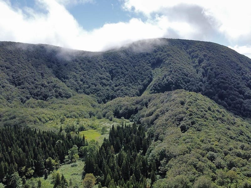
Lying to the east of Murayama City, Koshiki-dake (not to be confused with Koshiki-yama in Mamurogawa) is one of the 100 Famous Mountains of Tohoku. Koshiki-dake only just rises above 1,000m. The lone pyramidal peak of Koshiki-dake is one of the distinct parts of the Ou mountain range, reminiscent of the eroded remains of a once underwater volcano.
The name Koshiki-dake refers to the mountain’s resemblance to a Koshiki, a steaming basket used for cooking rice brought over to Japan from ancient China. The mountain boasts deeply eroded valleys, and some slopes of the mountain rise up at an angle of more than 30 degrees. The varied facets of nature to be seen on Koshiki-dake have led it to become a popular peak for mountain worship since ancient times.
Makui Trail (5.5 hours return)
The Makui Trail is the most used route up Koshiki-dake. The trail starts in the Tateoka region in the centre of Murayama City. Heading towards the Higashizawa Rose Garden from Murayama Station, follow the signs to the right. Go along the forest road and there is a lumberyard at the end marking the trailhead.
After crossing the bridge, you will come across a fresh water source, the Umatate-numa pond, and a chestnut forest. The trail takes you up a ridge from where it meets the Iwagami Trail. Then, just in front of where the trail meets the Niiyama trail, there is a rest area with outstanding views. From here, the summit is only about 10 minutes away. However, unfortunately there is no lookout since it is covered in beech trees.
Niiyama Trail (5 hours return)
The Niiyama Trail is the shortest trail to the summit and starts in the Niiyama area of Murayama City. Once through the Niiyama hamlet, head towards the forest road by taking a right at the stone torii gates. The trailhead is at the end of the forest road at a small shrine called “Yama no Kami”. Keep following the trail. When you pass the water trough, there is a junction to a lookout. There you can see the whole of Murayama City. This part is only 50m from the main trail, so is a great place to stop for a rest. After this, there is a cave, the remains of a mine, and a tainai kuguri (womb pass). Then the path meets with the Makui and Iwagami trails.
Iwagami Trail (7 hours 20 return)
The Iwagami Trail is the longest route to the summit of Koshiki-dake. However, it goes past the Komatsuzawa Kan’on temple and feels like you are traversing the mountain rather than climbing it. This trail was also the traditional trail to the summit. Heading straight through the forest road towards the Makui Trailhead, go along the Yama no Kami Shotoku Taishi Sonsando. Then, cross the mountain stream and take a right to get to the trailhead. The trail then takes you via its namesake, Iwagami-yama (Mt. Iwagami), and Ohira-yama. Then it links with the Hachika-sawa and Makui Trails.
Hachika-sawa Trail (5 hours return)
The Hachika-sawa Trail begins to the south in Higashine City. Heading towards the Ichinosawa-ike pond of the Nittogawa river, follow the signs along the unpaved forest road. The trailhead is right before the Kinokoen mountain hut where the signs are. Keep following the path up the Ichi-no-saka slope. Just past the remains of the Hachika Sanso (mountain lodge) the trail gets steeper. Eventually, the trail converges with the Iwagami trail and continues on to the summit.
Nearby locations worth visiting
Ginzan Onsen
Ginzan Onsen located in Obanazawa City is one of the most well-known parts of Yamagata Prefecture. Famous for its Ryokan along a river straight out of a Ghibli film, Ginzan Onsen is an excellent location to relax your aches and pains.
Switch on coffee

One day, I was passing through Obanazawa on my way home from Sendai. I found this cool little café had only recently opened. They had amazing cheesecakes, and their selection of beans was also rather extensive, something for everyone. The master there really knew his stuff too! A great little spot to visit.
Odo-Mori
One of the harder hikes in the region, Odo-mori (御堂森おどうもり) is a 1057m (3467 ft.) peak in the Murayama region. Odo-mori is a level 3 in terms of physical demand, which means it is moderate to hike. The mountain has an A technical grade, which means it requires little expertise. Allow at least 3 hours one-way for a climb up Odo-mori.
Ohira-yama
Lying in the Murayama region, Ohira-yama (大平山おおひらやま) is a 814m (2670 ft.) peak. Ohira-yama is a level 1 in terms of physical demand, which means it is easy to hike. The peak has an A technical grade, which means it requires little expertise. Allow at least 1.5 hours one-way for a climb up Ohira-yama.
Gosho-zan
Also known as Funagata-yama, Gosho-zan is a mountain on the borders of Yamagata and Miyagi Prefectures.
Kita-yama

Kita-yama is a converted ski field in the Murayama region of Yamagata prefecture. Kita-yama (北山きたやま) is the perfect spot for a picnic among the Sakura. The mountain offers panoramic views over the rice fields and mountains of inland Yamagata Prefecture.
Kamuro-dake
Kamuro-dake is a Mountain on the edge of a caldera on the borders of Mogami Town and the Onikobe part of Naruko Onsen, Miyagi Prefecture.
Futatsu-mori
Futatsu-mori is a distinctive twin-peaked mountain in Obanazawa City near the border with Miyagi Prefecture.
Venerable Old Man Mountain — The Mist and Mystery of Okina-san
Venerable Old Man Mountain Okina-san (翁山おきなさん, Mt. Okina) lies along The Ou Mountains. The landscapes and legends of Okina-san make this 1075 m (3526 ft.) peak not only a 100 Famous Mountain of Yamagata, but also one of the 100 Famous Mountains of Tohoku.
KOSHIKI-DAKE
甑岳 | こしきだけ
Mt. Koshikidake, Koshikidake, Mt. Koshiki
Koshiki-dake (甑岳こしきだけ) is a 1016m (3333 ft.) peak in the Murayama region of Yamagata prefecture best climbed from June to October. Koshiki-dake is a level 3 in terms of physical demand, which means it is moderate to hike, has a A technical grade, which means it requires little expertise, and you want to allow at least 5 hours for a climb.
Mountain Range
Ou Mountains
Region
Murayama
Elevation
1016m (3333 ft.)
Technical Demand
A (requires little expertise)
Physical Demand
3 (relatively demanding)
Trails
Four. 1) Makui Trail (5.5 hours return), 2) Niiyama Trail (5 hours return), 3) Iwagami Trail (7 hours 20 return), 4) Hachika-sawa Trail (5 hours return)
Best time to climb
June to October
Day trip possible?
Yes
Minimum Time Required
5 hours return
PDF Maps by TheHokkaidoCartographer and JapanWilds.org. See all here.
100 Famous Mountains of Tohoku, 100 Mountains of Yamagata, Autumn Leaves, Buddhist Temples and Shinto Shrines, Forest Bathing, Full Day Hikes, Goshozan Range, Hard to reach, Higashine City, Hiking Guides, Historical Hikes, Mountains above 1000m, Murayama City, Murayama Region, Myths and Legends, Ou Mountain Range, Waterfalls, yamabushi


YAMABUSHI NEWSLETTER
KIWI YAMABUSHI

TIM BUNTING - KIWI YAMABUSHI