Yamagata’s Secluded Secret: Takatori-yama (Mt. Takatori)
たかとりやま
高取山
TAKATORI-YAMA
Small peak on the edge of Nakayama Town famous for its Kannon Temple and the views it commands.
Takatori-yama is very much a locals’ mountain. It’s not especially famous, and it doesn’t have the grand aura of Zao or Gassan. Yet that’s exactly what makes it so refreshing; a quiet, brisk hike through forest, farmland, and viewpoints that connect you to the everyday landscapes of Yamagata.

Takatori-yama is a mountain with a summit covered in ancient pine trees on the northern edge of Shirataka Hill in Nakayama Machi. The trail boasts views of Gassan, Zao-san, and the Asahi Renpo, as well as the sacred mountain Iwayakannon-yama complete with Iwayajuhachiya Kannon (a temple with a statue of Kannon), as well as the Murayama basin.
Getting to Takatori-yama
Finding the right starting point can be tricky. We first ended up at Yamagata Celltop carpark, on the wrong side of the Shin and Oka trailheads. Eventually, we drove all the way around to the trailhead, but I wouldn’t recommend this without a 4WD, there are some very steep parts with sharp turns.
A better option, and what the only other hikers we saw did, is to park at Okamura Kannondo Temple. From there, simply follow the road west until you reach the trailhead near this spot.
The trailhead itself was partly hidden by trees, but a noticeable gate marked the spot. The Shin Trail “sign” was misleading, it only said “don’t litter.” By contrast, the Oka Trailhead had a proper sign, though you had to step a little way down the path to see it clearly.
Hiking Takatori-yama

We took the Shin Trail up and the Oka Trail down. The Shin Trail is said to take about 35 minutes to climb, with the Oka Trail taking around 20 minutes to descend. That timing proved accurate for us, breaks included.
The Shin Trail winds through dense forest, passing small mountain streams and even opening suddenly to reveal what looked like a hidden rice field. A few narrow sections showed signs of landslides, but nothing dangerous. The path generally contours around the mountain before heading up toward the summit.
Spider webs were plentiful, a good sign this mountain doesn’t see heavy foot traffic, and the sheer variety of mushrooms surprised us. We also spotted more than a few skinks darting across the path. At one point, a wave of insects scuttled aside as I walked through, briefly giving me the strange feeling I was controlling them.
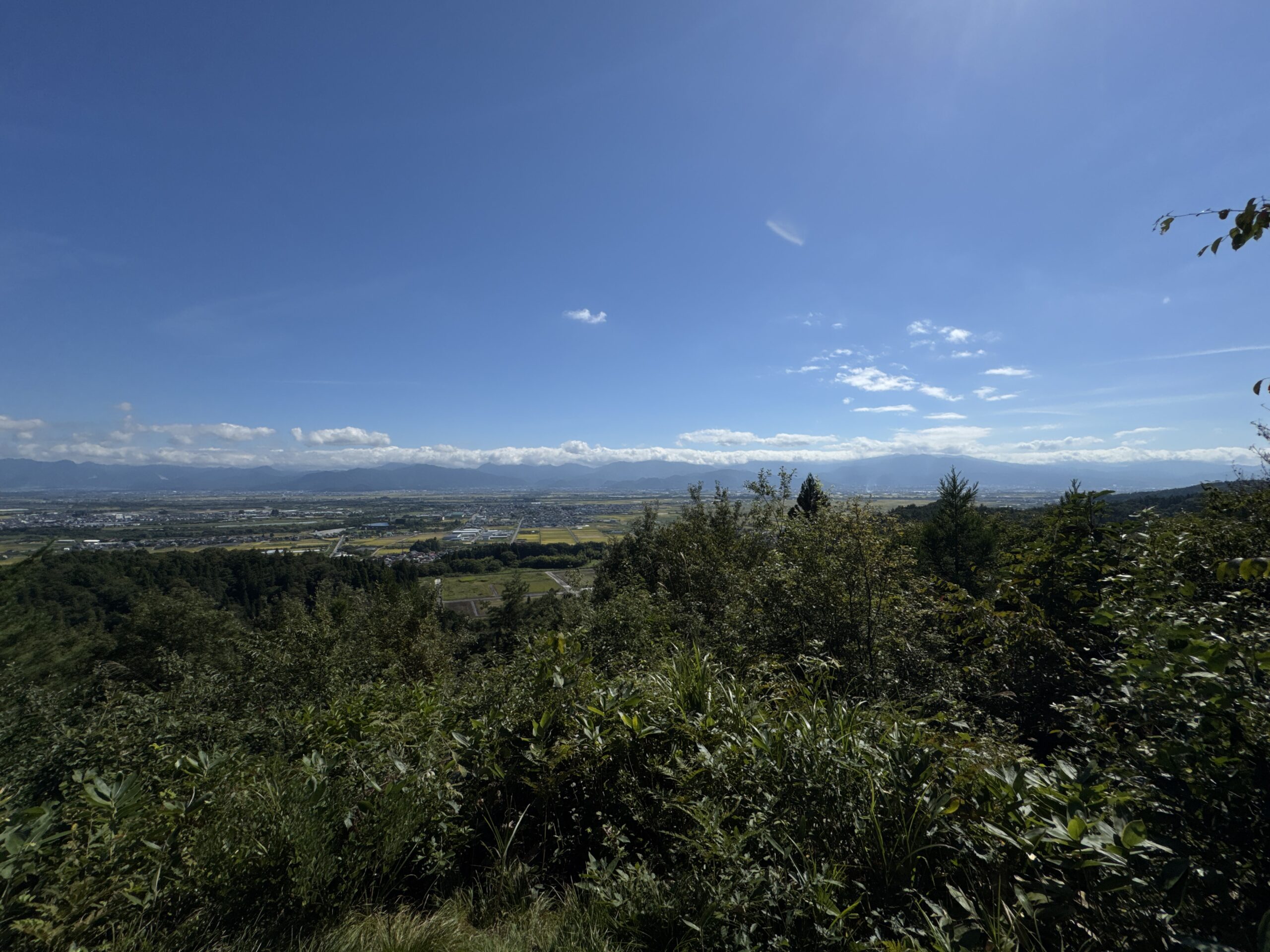
From the lookout, we were rewarded with wide views over Zao-san and the mountains around Yamagata, Tendo, Higashine, and Sagae, with Nakayama Town in the foreground. The view reminded me of Tokami-yama a little further south.
After a short detour to pay our respects at the shrine by the lookout, we headed down via the Oka Trail. The fork for the Dobashi Trail appeared along the way, but sticking to the Oka route, it was only about 20 minutes back to the car.
Overall impressions
Takatori-yama is best described as a New Zealand–style bushwalk: short, brisk, and easily done in around an hour. It may not be remarkable compared to Yamagata’s larger peaks, but it’s a peaceful local escape with forest trails, farmland surprises, and sweeping views of the surrounding basins and mountains.
Nearby, the Iwaya Kannon Temple is worth a visit. This place was historically a training ground for Onakama, blind mediums similar to the Itako of Aomori. That connection gives Takatori-yama an added layer of cultural significance within the spiritual landscape of Yamagata.
Trails up Takatori-yama
There are three trails up Takatori-yama in total locals use throughout the year. It’s possible to go up and down on different trails, and there are trails for beginner hikers too. In winter, Takatori-yama is popular among snowshoe enthusiasts.
Dobashi Trail (30 minutes one-way)
The Dobashi Trail is the easiest of the three trails and that hikers of all levels love. Heading west from Toyoda Elementary School, keep following the signs leading to the trailhead. There is space near the trailhead to park your car. The trail has some ups and downs, but overall it is not too steep and well maintained. There are benches and signs telling you the halfway point, so you can climb up at your own pace.
Just before the summit there is the Shinzoyaburi-no-Saka slope that is a bit tough to climb, but there are also other not-so-steep trails you can take. Just head east of the summit there is an open area with a lookout from where you can see Yamagata and Tendo Cities, as well as the Zao Renpo, Futakuchisan-kai, and the Funagata Renpo.
Shin Trail (30 to 40 minutes one-way)
The trailhead for the Shin trail is located to the north of Yamagata Celltop. Don’t head to Yamagata Celltop normally though! Make sure you go around through the Oka hamlet. There is a small incline at the start that gradually increases after the wooden bridge and inside the cedar forest. Once at the top, head south along the northern ridge. In early spring and late autumn you can see the Asahi Renpo through the trees. Take a left at the last junction, and you’ll find yourself at the summit.
Oka Trail (20 minutes one-way)
Park your car at the same spot as the Shin Trail, right in front of the gate. Follow the wall past the gate to the west where you’ll see signs for the trial. The Oka trail is rather level at first, but after a while you hit the western side and a long incline. Take note, along the way there are parts that get very muddy. Once at the top of the incline, the trail meets with the Dobashi Trail, and you’re essentially at the summit.
Places Nearby Worth Checking Out
Onigiri Rice Ball Mountain: Chitose-yama
Chitose-yama is a triangular rice-ball-shape mountain in Yamagata City famous for its red pine forest, and the legend of Akoya-hime, Princess Akoya.
Loaction of Tohoku's Battle of Sekigahara: Togami-yama
Togami-yama is a triangular mountain that was the location of one of Japan’s fiercest battles, and was the reason why Yamagata Castle was named Kajo.
TAKATORI-YAMA
高取山 | たかとりやま
Mt. Takatori, Mt. Takatori-yama, Mt. Takatoriyama, Takatoriyama
Takatori-yama (高取山たかとりやま) is a 271m (889. ft.) peak in the Murayama region of Yamagata prefecture open year-round. Takatori-yama is a level 1 in terms of physical demand, which means it is easy to hike. The mountain has an A technical grade, which means it requires little expertise. Allow at least 30 minutes one-way for a hike up Takatori-yama.
Mountain Range
Takatori-yama
Region
Murayama
Elevation
271m (889. ft.)
Technical Demand
A (doesn't require much expertise)
Physical Demand
1 (easy to hike)
Trails
Three: 1) Dobashi Trail (30 minutes one-way), 2) Shin Trail (30 to 40 minutes one-way), 3) Oka Trail (30 to 40 minutes one-way)
Best time to climb
Year-round
Day trip possible?
Yes
Minimum Time Required
1 hour
PDF Maps by TheHokkaidoCartographer and JapanWilds.org. See all here.


YAMABUSHI NEWSLETTER
KIWI YAMABUSHI

TIM BUNTING - KIWI YAMABUSHI